Back هوت العليا ARZ Upper Hutt (lungsod sa Nuzeland) CEB Upper Hutt English Upper Hutt Esperanto Upper Hutt Spanish Upper Hutt French Upper Hutt Scots/Gaelic Upper Hutt ID Upper Hutt Italian აპერ-ჰატი Georgian
| Upper Hutt Upper Hutt City Māori: Orongomai | |
| Geographische Lage | |
 Lage von Upper Hutt City | |
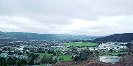
| Foto von Upper Hutt | |
 Blick auf Upper Hutt City | |
| Gebietskörperschaft | |
| Staat | Neuseeland |
| Insel | Nordinsel |
| Region | Wellington |
| Gebietskörperschaft | City |
| Council (Rat) | Upper Hutt City Council |
| Bürgermeister | Wayne Guppy |
| Gründung | 1840 unter Hutt County, ab 1908 eigenständig |
| Postleitzahl | 5018, 5019 |
| Telefonvorwahl | +64 (0)4 |
| UN/LOCODE | NZ UBA |
| Website | www.upperhuttcity.com |
| Präsentation | |
| Wahlspruch | A great place to live (Ein großartiger Ort zum Leben) |
| Geographie | |
| Region-ISO | NZ-WGN |
| Koordinaten | 41° 7′ S, 175° 4′ O |
| Höchste Erhebung | 862 m |
| Niedrigste Erhebung | 27 m |
| Fläche | 540 km2 |
| Einwohner | 40 179 (2013[1]) |
| Bevölkerungsdichte | 74,41 Einw. pro km2 |
| Statistische Daten | |
| Öffentl. Einnahmen | 42,6 Mio. NZ$ (2015[2]) |
| Öffentl. Ausgaben | 49,6 Mio. NZ$ (2015[2]) |
| Anzahl Haushalte | 16 056 (2013[1]) |
| Ø Einkommen | 32.000 NZ$ (2013[2]) |
| Bevölkerungsanteil Māori | 13,3 % (2013[1]) |
Upper Hutt, offizielle Bezeichnung: Upper Hutt City, auf Maori Orongomai, ist eine Stadt und zugleich eigenständige Territorial Authority (Gebietskörperschaft) in der Region Wellington im Süden der Nordinsel von Neuseeland.